With a team of qualified and experienced professionals with multi-disciplinary backgrounds, Murphy Surveys’ Digital Engineering department is an essential partner for projects that require Laser Scanning and Building Information Modelling (BIM) for geospatial certainty.
The terrestrial laser scanner was invented during the last decade of the 20th century and has quickly progressed to be an industry standard. It is now the preferred and most efficient tool to accurately capture three-dimensional geometry of the built environment. Modern survey grade laser scanners are capable of capturing millions of 3D coordinates per second with millimetre accuracy.
Murphy Surveys’ Digital Engineering team is equipped with the essential tools and know-how to support on-site 3D surveying requirements, providing the CAD and BIM deliverables that are consistently required by design and construction teams. Bringing the highest level of expertise to the market, we have been pioneers in providing advanced Building Information Modelling results, building upon over 35 years of history and experience in supplying quality services to the AEC sector.
Our client Dunnes Stores has recently acquired the Café Sol chain which originally comprised of eight coffee shops in Dublin. The retail outlet is rebranding the café chain and plan to replicate the new look brand across their stores. Our digital engineering team met the project team to discuss the possibilities around 3D representations and BIM to help them during the design and planning process. Through collaborative consultation it was agreed that a 3D survey would benefit Dunnes Stores during the work involved in the Café Sol scheme as it would provide an accurate and realistic digital representation of the café.
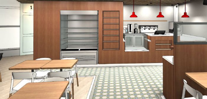
Murphy Surveys was commissioned to provide Dunnes Stores with this digital representation using BIM. The BIM model depicted the site conditions of their first redesigned space, which recorded the existing layout while detailing all components and fittings. Dunnes Stores intend to make the brand consistent across all sites therefore given that each store has a different floor area for the cafés, the digital model provided by Murphy Surveys will support this process, as it offers a realistic picture of an existing location in a 3D BIM format.
Our team measured the café using 3D laser scanning and High Dynamic Ranging (HDR) photography, producing detailed point clouds and panoramic images that were later used to create the 3D model. Autodesk Revit was the BIM package used for this task. Tailored Revit components (families) were developed, bearing in mind that most of the components and furnishings were bespoke and not part of standard object libraries. The final deliverable incorporated all features, including floor finishes, equipment and furniture, exactly representing in digital form the objects and arrangement visible on the ground.
With the use of automated custom scripts we populated the model with asset information as required by the original project brief, further complementing the LOD (Level of Detail) 500 model. LOD 500 gives high geometric detail thus replicating exactly the geometry of all objects, including equipment such as coffee machines. Revit components were developed with the appropriate parameters, replicating the asset register that was previously stored in a simple spreadsheet. Dunnes Stores can benefit from the three-dimensional model during the rebranding project and throughout the operations and maintenance tasks.
Murphy Surveys has worked on numerous retrofit projects for Dunnes Stores and are constantly conveying 3D deliverables that benefit the entire project lifecycle and specially the design and construction processes. We completed a pilot immersive reality survey of their Georges Street store demonstrating the technology and the potential applications of 3D cameras. Furthermore, our survey teams continue to support a variety of requirements: roof inspections using Unmanned Aerial Vehicles (UAV), internal floor plans, floor flatness analysis and more.
The degree of accuracy consistently achieved throughout all our projects has strengthened our reputation as one of the most technically proficient survey companies in Ireland and the UK today. We strive for excellence in all aspects of our work.


