

As the Irish economy performs strongly, the latest figures reveal that investment in real estate is a multibillion euro industry, with over 2.5 billion alone being invested in the commercial real-estate sector. Chartered Geomatics Surveyors are an essential player in this important sector. Professionals that truthfully digitise the built environment, providing verifiable as-built deliverables that include building information models.
Murphy Surveys commission the latest digital tools to accurately capture comprehensive 3D point cloud data, recording the built environment with extraordinary detail and accuracy, regardless of the nature or use of the building. The point clouds and imagery datasets captured on site support drafting and modelling tasks, an offline process that enables the development of dependable and authentic digital copies of reality.
Building information models are gradually becoming the central building block of the design and construction process for redevelopment schemes, echoing the Government’s national ‘Construction 2020’ strategy and the initiatives of the National BIM Council of Ireland that promote the use of digital technology and the implementation of BIM Level 2 during design, construction and operation processes.
 Our digital engineering team employs laser scanning units and high dynamic range imaging devices to execute the site measurement tasks. Ultimately, this valuable data is used to develop intelligent and parametric models of the existing structures, notwithstanding the conceptual nature of some elements, namely where the exact nature of the construction is unknown. It is now commonly accepted in the industry that BIM is now regarded as the optimum tool to share project and asset information, replacing the traditional 2D computer aided design drawings.
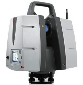
Our organisation is frequently commissioned with the task of delivering as-built information, digitising existing environments ahead of redesign or repurposing work. On a typical project, the surveying team begins by establishing a coordinate system that is linked to the national mapping grid, guaranteeing that the deliverable is fully coordinated and thus suitable to be viewed and studied by the planning authorities, as required. Starting off these fundamental reference points, the surveying teams then acquire laser scans and high-resolution imagery (Figure 1) throughout the building, ensuring that all detail is captured and documented with rich and clear datasets.
An offline coordination process in an office environment enables the validation and linking of the point clouds and images, creating a single and coherent dataset that is used to produce semantically rich deliverables.
Subsequently, the 3D data is referenced within the BIM software platform and used to precisely place and model the relevant components. Bespoke parts are created as required, parametric components and associated parameters (description, function, unique ID’s, etc.) are shaped, mimicking the precise geometry provided by the 3D point clouds (Figure 2).
Representing different disciplines in distinct models results in added convenience, maintaining the contents logical, fully coordinated and clash free in a single federated model, Asset and project information is accurately mapped onto 3D representations, providing a graphical environment in which all data for all areas is immediately accessible to the entirety of the team members.
The smart and efficient use of technology brings enhanced value to all project stockholders, transporting existing realities onto rich visual software packages that allow for better project outcomes. Design activities are streamlined when exploring the three-dimensional graphical output of the as-built surveys, improving the design quality and encouraging new and innovative solutions for ordinary problems.
Additionally, the intelligent datasets can be used as an asset registry, facilitating facility management activities by allowing the automatic generation of schedules or registries for example.
Operating from 11 offices throughout Ireland, the UK and mainland Europe Murphy Surveys work with public and private sector clients from a vast range of industries across the globe. In 35 years, we have grown to employ more than 200 staff. Key factors in our success include stringent quality control, efficient turnaround times, and effectiveness to provide superior customer service always. Our continual investment in the latest surveying equipment and technology allows us to provide the most efficient solutions that cut costs and risks for our clients. As a result, we are widely recognised as one of the most experienced, professional, innovative and technically proficient surveying companies in the industry.
The contents of this site are subject to copyright laws and may not be reproduced in any form without the prior consent of the publishers. The views expressed in articles do not necessarily represent those of the publishers.
 Built for Designers")

