Global positioning partner for geo-businesses, Topcon, has helped Caintech Ltd. increase surveying accuracy and safety in the Scottish mountains following the purchase of a Sirius Pro.
For the Inverness-based surveying company, acquiring the unmanned aircraft system (UAS) has allowed them to diversify their business offering – from the scale and complexity of projects they are involved in, to the industries in which they operate.
Established in 1989, Caintech was initially involved with quantity surveying but for the past nine years has shifted to being predominately involved with land surveying – carrying out topographic, bathymetric and laser scan surveys.
In 2014, the firm decided to expand its capabilities so that it could undertake more detailed surveys over wider areas. Tim Riome, chief pilot at Caintech, was responsible for choosing a suitable aerial mapping system for the firm and, with an aviation background, had strict requirements for a robust and reliable vehicle.
“Our surveying teams were using terrestrial laser scanning and photogrammetry to image capture across some of the UK’s most remote locations,” said Mr Riome. “Information was gathered from multiple setups and merged into a single dataset during processing. This required pre-surveyed ground control points which restricted the areas we could cover.”
The harsh conditions of the Scottish Highlands were a key issue for the company’s survey teams, often casting limitations on the scale of their work. Teams were spending weeks in the field, working across tough terrain and in extreme weather.
“We needed a solution that was durable enough to overcome the limitations of the hostile environment while decreasing the time the team spent on the ground,” said Mr Riome.
Caintech chose the Sirius Pro aerial mapping system from Topcon as it can create aerial maps and digital terrain models while being fully operational in constant wind speeds up to 50kmph, gusts up to 65kmph and even in the rain.
The Sirius Pro surveys to a high degree of accuracy across demanding areas while its built-in navigation system (RTK GPS) eliminates the need for ground control points, making it ideal for challenging projects like those undertaken by Caintech.
“From an aviation point of view, we found that the Topcon Sirius Pro was the most robust system out there, offering the most stable and steady platform with high quality imagery, zero vibration and steady landing,” added Mr Riome.
One of the firm’s most notable surveys using the Sirius Pro has been for a new cable track over a Scottish mountain at elevations over 860m. Jim Main, managing director at Caintech, explains: “It required the UAS to travel at an altitude of around 1km above sea level to survey the mountainous regions. With the Topcon Sirius Pro, we can now take on all the projects we are approached to undertake and can offer competitive prices as we have the technology and, therefore, the capacity”.
Since gaining the Sirius Pro, Caintech has widened the business’ offering to include wind farms, power lines and quarries – all of which cover vast areas.
[rev_slider CITA]
Mr Riome said: “By introducing the Sirius Pro to Caintech, we no longer need to expose our staff for long periods of time to hostile and possibly dangerous locations. Large projects which previously demanded two or three survey teams working on site for a few weeks now require just one operator in the field for a maximum of four to five days.”
On one occasion, a client wanted to find out how far excavation had progressed on a construction project and called on Caintech to determine the volume of material which had been moved.
Mr Riome explained: “The first thing we did was to call up the map of the location for the site, then we carefully marked out the exact area we wanted to survey. I then pressed a button on the system and it created the UAS’ flight plan. All we then had to do was just take it to the site and it was ready to go.
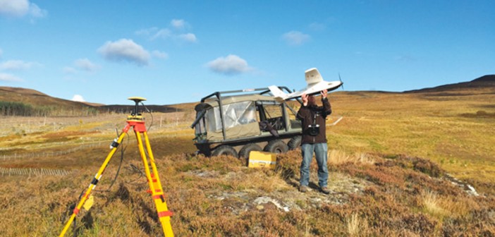
“The flight plan was uploaded onto the UAS wirelessly from a laptop at the site, and the unit was then launched by hand – with no cumbersome catapult or launch rails to install in the ground to set it off.

“Back in the comfort of the office, we used the information to create a digital elevation model. Orthographic photos of the site were then literally draped over the model to produce a dimensionally accurate model which showed all the site’s features.
“Not only has the Sirius Pro led to huge safety benefits for our staff, but it has improved cost and time efficiencies too. As the business continues to expand exponentially, we are looking to purchase more Sirius Pro’s and to recruit more operators.”
For more information about Topcon, visit http://global.topcon.com/


